Next: The 100 Shops Task »»
«« The Design a Flag Task
Sourcing mats from 100 locations ‘across China’ raises many thorny questions. Where should they be resourced? Do we want representation to be equitable? Representative of what? Equitable for whom? Does geography matter? Ethnicity? Income? Modernity? Poverty? Power?
A question was posted to social networking site Weibo, and 31 people engaged in identifying locations that represented ‘across China’. From the list of suggestions we decided to source from 4 municipalities e.g. Beijing, Tianjin; 5 ethnic autonomous regions e.g. Inner Mongolia, Tibet; 23 provinces e.g. Hei Long Jiang; Tai Wan; and 2 special administrative regions i.e. Hong Kong, Macao. Within this list there was plenty of scope to drill down to exact cities, towns or villages – so for guidance we turned to research site Diaochapai (调查派, akin to SurveyMonkey) and taking advantage of the heightened travel activity in the Spring Festival we posted a survey asking which towns/cities were considered representative of each province.
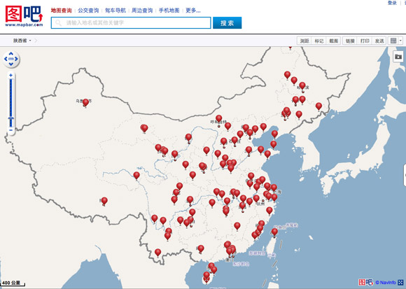
The design of the questionnaire was iterated based on feedback from the crowd. The 100 locations were logged in a spreadsheet and can be viewed local mapping service MapBar. We originally used SouGou for mapping but switched to MapBar after frustrations with the map interface.
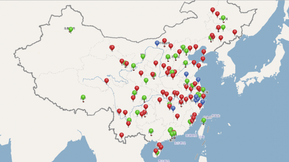
The above map shows the original list of preferred 100 locations – view online here, (and jumping ahead to the outcome of next task, but posted here for easier comparison) the below map shows the final tally of 100 locations based on actually shops purchased from – view online here. In the below map green shows the preferred locations where mats were bought; red shows ones where shops were not easily located; and blue – were not in the original list of 100 preferred cities, but made the final cut.
As anyone who has worked with map services knows – maps are inherently political: the position of borders; what is emphasised; what is hidden; the names that are adopted – these are all grounded in the world view (and regulatory landscape) prevalent in that country. Many international map service providers defuse this sensitivity, in part by serving up different maps depending on location of the computer making the request. In keeping Rule 4 – Chinese map services were used in this experiment.
Next: The 100 Shops Task »»
«« The Design a Flag Task


